Sobha Hennur Map
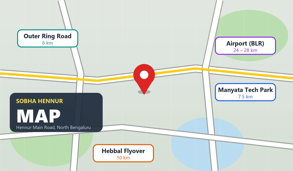
The Sobha Hennur Map shows the exact location of this big 45-to-50-acre luxury apartment township on Byraweshwara Layout Road, Chikkagubbi Village, just off Hennur Main Road (Hennur-Bagalur Road) in North Bengaluru, Karnataka 560077. It sits right between the Outer Ring Road (ORR) IT hub in the south and the Kempegowda International Airport in the north. The map shows direct roads and upcoming metro lines that connect people to Manyata Tech Park, Hebbal, and Devanahalli in just 15 to 40 minutes. Whether you travel to the office every day or want to invest in property, looking at this project map helps you see how this prime North Bengaluru address saves travel time while keeping good schools, hospitals, and malls very close by.
Understanding the Sobha Hennur Map & Exact Coordinates
When homebuyers look at the Sobha Hennur Map, the first thing they notice is its great spot on the New Airport Road (Hennur-Bagalur Road). Unlike crowded city areas, this part of North Hennur has wide roads and lots of green trees.
- Official Site Address: Byraweshwara Layout Road, Chikkagubbi Village, off Hennur Main Road, North Bengaluru – 560077.
- Immediate Neighbourhoods: Kothanur, Byrathi, Gubbi Cross, and Thanisandra.
- Key Arterial Roads: Hennur-Bagalur Main Road, Outer Ring Road (ORR), Thanisandra Main Road, and Bellary Road (NH-44).
- Land Scale: A 45-to-50-acre big gated community with tall apartment towers, wide inside roads, and over 75% open green space.
Transit & Commute: Distances on the Sobha Hennur Map
A location map is most useful when it shows real travel times. Because the project is near the Gubbi Cross junction, people living here can take the back road to the airport (via Bagalur). This helps you fully skip the heavy traffic and toll gate on Bellary Road.
| Landmark / Transit Hub | Route from Project | Distance | Estimated Drive Time |
|---|---|---|---|
| Nagawara Junction & Metro (Upcoming Blue Line) | Hennur Main Road South | 4 – 6 km | 10 – 15 Mins |
| Outer Ring Road (Hennur Cross Junction) | Hennur Main Road | 6 km | 15 – 20 Mins |
| Manyata Embassy Business Park | Hennur Cross to ORR | 7.5 km | 20 – 25 Mins |
| Hebbal Flyover (NH-44) | ORR Westbound / Thanisandra | 10 km | 20 – 30 Mins |
| Kempegowda International Airport (BIAL) | Hennur-Bagalur New Airport Road | 24 – 28 km | 35 – 40 Mins |
| MG Road (Central Business District) | Hennur Road via Cox Town | 14 km | 40 – 50 Mins |
| SMVT Railway Station (Baiyappanahalli) | ORR Southbound | 11 km | 25 – 30 Mins |
Major IT Parks & Employment Hubs Near the Project
North Bengaluru is growing very fast with many new jobs. If you look at the Sobha Hennur Map, the project is right between two big work areas: the main ORR IT belt and the fast-growing Devanahalli Aerospace Park.
- Manyata Tech Park (20 Mins): Big companies like IBM, Cognizant, Target, Nvidia, and Nokia are here, with more than 1.5 lakh workers.
- Karle Town Centre & Kirloskar Business Park (20–25 Mins): Located right next to Nagawara Lake and Hebbal.
- Bhartiya City IT Park (12–15 Mins): Located just across the Thanisandra link road, making it very easy and quick for tech workers to reach the office.
- KIADB Aerospace Park & Devanahalli Business Park (30–35 Mins): A huge 3,000-acre work zone near the airport where Boeing, Airbus, SAP Labs, and big data centers are built.
Social Infrastructure Around the Sobha Hennur Map
Every family needs daily needs like schools and shops within 5 to 10 kilometers. Hennur Main Road has grown from a quiet area into a busy spot with top schools, big hospitals, and shopping malls.
Top Schools & Colleges (5 to 20 Mins)
- Legacy School & United International School (Off Hennur Road)
- Bangalore International School (Geddalahalli, Hennur)
- Kristu Jayanti College & New Baldwin International School (Kothanur)
- Vidyashilp Academy & Vibgyor High (Jakkur / Horamavu)
Healthcare & Hospitals (10 to 25 Mins)
- Cratis Hospital (Hennur Main Road)
- Manipal Hospital & Aster CMI Hospital (Hebbal)
- Cloudnine Hospital (HRBR Layout)
- Regal Hospital (Chokkanahalli)
Shopping, Dining & Entertainment (10 to 25 Mins)
- Phoenix Mall of Asia (Byatarayanapura/Bellary Road): One of the biggest luxury malls in North Bengaluru.
- Elements Mall (Thanisandra Main Road): A good place for movies, buying groceries, and eating out.
- Bhartiya Mall of Bengaluru: Just a 12-minute drive using the inside Kothanur-Thanisandra link road.
- Kalyan Nagar & HRBR Layout High Street (15 Mins): Full of popular restaurants, cafes, supermarkets, and clothing shops.
Inside the Township: What the Master Plan Map Shows
Along with outside roads, the inside Sobha Hennur Map (master plan) shows how the 45-to-50-acre land is planned for a happy and safe family life:
- Residential Zones: Tall towers are built with plenty of space between them so every 1, 2, 3, and 4 BHK flat gets open views, bright sunlight, and fresh air.
- Vehicle-Free Podiums: Cars and bikes move only on the outer ring road of the project. This keeps the center garden, kids' play areas, and walking paths safe for people walking around.
- Central Clubhouse Zone: Built right in the middle so everyone can reach it easily. It has a swimming pool, indoor games rooms, and office work spaces.
- Retail & Convenience Plaza: Placed near the main entry gate so families can buy daily milk, vegetables, and medicines without going out onto the main road.
Why This Location Map Drives High Property Appreciation
For people who want to invest money, property prices on the Hennur-Bagalur road have gone up steadily over the last five years. Three big road and metro projects are increasing the value of this area:
- Namma Metro Blue Line (Phase 2B): The ORR-Airport metro line passing through Nagawara and Hebbal will cut travel time to Silk Board and the Airport to less than 30 minutes.
- Peripheral Ring Road (PRR) / Bengaluru Business Corridor: Once this road opens, it will connect Tumkur Road and Hosur Road straight to Hennur and Bagalur, letting you skip city traffic.
- Alternative Airport Highway Widening: The wide state highway connecting Hennur to Bagalur and the Southwest gate of the airport makes this the best toll-free airport road for people in East and North Bengaluru.